Princess Juliana International Airport handles only about 60,000 aircraft movements a year (compared to almost 500,000 at Heathrow) but it is renowned the world over because of its layout. One end of the 2,000 m/7,000 foot runway (10/28) is very close to Maho Beach and the low approaches are very popular on Youtube. There are many videos of the low planes seemingly coming in to land only a few feet over the beach and also of the beach goers who enter the area directly behind the runway to let the jetwash flow over them, holding onto the fence to attempt to keep them from being blown over. There have been many injuries and now one death from tourists being knocked over by the jet blast. However, I was surprised to discover that the airport has never had a serious aviation accident despite the tricky approach. The only clear case I could find was ALM Antillean Airlines flight 980, a scheduled flight from New York to the island of Sint Maarten, where the McDonnell Douglas DC-9 was unable to get into Princess Juliana airport because of the weather. After several unsuccessful landing attempts, the aircraft was low on fuel and the captain announced that he intended to ditch the aircraft. The purser believed that the announcement was a precautionary measure and presumed that they would be given further information if it was actually necessary to ditch.
The cabin crew were helping the passengers put on their life vests when the aircraft impacted the water. Many of the passengers were standing or did not have their seatbelts on, resulting in 23 fatalities (22 passengers and one cabin crew). Warn passengers is now included in the checklist for emergency landings and ditchings as a result of this accident along with the requirement that commercial flights must have a working PA system.
But that’s not the incident I’m writing about today. This one has a happy ending.
This post is based on Aviation Investigation Report A17F0052: Risk of collision with terrain by the Transportation Safety Board of Canada.
The incident took place last year on the 7th of March in 2017. Times are given in Atlantic Standard Time (AST) which is UTC-4, the local time in Sint Maarten. Because the occurrence was originally assessed by WestJet as a non-reportable event, the cockpit voice recorder and the digital flight data recorder data were overwritten and do not form a part of the analysis.
The aircraft was a Boeing 737-800, registration C-GWSV, operated by WestJet airlines. On that day, it was flying WestJet flight 2652, a scheduled IFR flight from Toronto, Canada, carrying 158 passengers, two flight crew members and four cabin crew members. Before they departed, the flight crew recieved a flight release package which included all the information deemed to be pertinent to the flight, including up-to-date weather information and details of the airport and runway. The forecast was for visibility greater than 6 miles (9,700 metres), with scattered cloud at 2,200 feet and at 3,000 feet.
The flight departed Toronto Pearson International Airport (CYYZ) at 11:37 AST for the four and a half hour trip at FL350 (35,000 feet above mean sea level). The captain, in the left seat, was Pilot Monitoring, the first officer was Pilot Flying.
The flight was uneventful and soon they were approaching Sint Maarten. The flight crew listened to the Automatic Terminal Information System (ATIS) which reported unlimited visibility, few clouds at 1,400 feet and no weather conditions of significance in the vicinity.
They prepared for a visual approach to runway 10. They also loaded the RNAV (GNSS) approach to the runway in the Flight Management System (FMS) and conducted the briefing as a precaution in case the weather worsened.
An RNAV (GNSS) approach means an area naviation (“RNAV”) procedure which requires a global navigation satellite system (GNSS). The important point here is that it is an instrument procedure specifically for use in bad weather or low visibility.
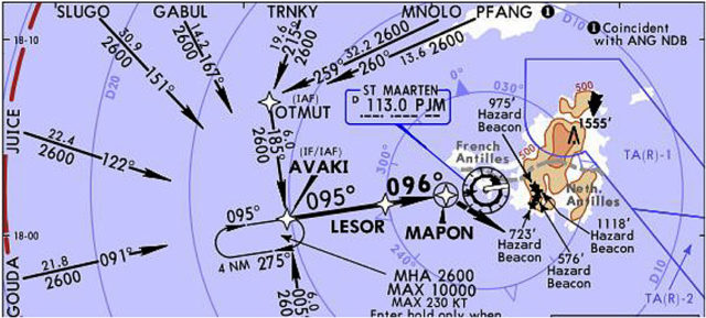 Jeppesen approach chart showing the RNAV (GNSS) Rwy 10 approach
The controller was in contact with the Westjet flight throughout the approach.
The controller spoke to the WestJet flight crew, instructing them to fly direct to the AVAKI initial approach waypoint once they had descended through 8,000 feet above sea level and that there were moderate to heavy rain showers at the airport. The flight crew, who were descending through 9,800 feet at the time, did not acknowledge.
At the same time, the ATIS (Automatic Terminal Information Service, a continuous broadcast of essential airport details including weather and runway information) was updated to Information November, and stated that the visibility had dropped to 2,000 metres (just over one nautical mile).
The minimum visibility for an RNAV (GNSS) approach for that aircraft category at Princess Juliana is 3,600 metres (1.94 nautical miles).
The crew didn’t pick up the new ATIS information, nor did they acknowledge the weather warnings from the controller. It’s pretty obvious that they had no idea that the weather had worsened to the extent that it was no longer safe to continue their approach to the airport.
A few minutes later, the controller repeated his instruction to fly direct to the AVAKI initial approach point and then, as the aircraft descended through 6,700 feet, the controller instructed them to continue their descent to 2,600 feet.
At 15:28, four minutes after the ATIS had been updated to show limited visibility below the minimums required, the aircraft was cleared to fly the RNAV approach to runway 10.
The controller said again that there were moderate to heavy rain showers at the airport. The flight crew, who were now 12 nautical miles west of the airport and descending through 3,700 feet, acknowledged the weather.
Another aircraft in front landed safely and reported steady winds and reduced visibility. They said they had ‘visually acquired the runway’ as they passed the missed approach point (MAP) — that is, they were able to continue their approach as they had visual contact with the runway at the last moment before they would have had to go around and try again.
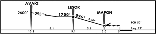 Descent profile for the RNAV (GNSS) Runway 10 approach (Jeppesen Sanderson Inc., approach chart)
The WestJet flight crew acknowledged the previous plane’s report. They were now on final approach, 10 nautical miles from the airport, descending through 2,100 feet.
The controller realised that the visibility was declining and decided to turn on the runway lights, using the automatic setting for night operation. This turned the runway edge lights on at 3% intensity. At the same time, the PAPI (Precision Approach Path Indicator, a set of red and white lights used to confirm the glide slope as the aircraft approaches the runway) were reduced from their daytime 30% to the nighttime setting of 10%. There was no manual or guidance available to the controller as to how to operate the lighting system or how to control the intensity depending on the conditions. His changes did nothing to improve the visibility of the approach.
As the WestJet flight reached 4.5 nautical miles from the airport and descending through 1,600 feet, the controller cleared it to land, still not reacting to the reduced visibility which had been clearly listed on the ATIS. There wasn’t enough visibility to carry out the approach but somehow this information wasn’t sinking in.
The Westjet’s aircraft rate of descent was between 700 and 800 feet per minute. But the aircraft, which had been following the approach path perfectly well up to this point, began to deviate. The descent angle dropped by 3° and the descent rate increased.
Now as a part of the standard approach procedures for WestJet aircraft flying into Juliana, the ‘flight directors’ need to be cycled on final approach. This simply means that the flight crew turn the flight director system OFF and then ON again. This ensures that the system doesn’t try to continue to the next waypoint and display an instruction to turn. The immediate effect is that the command bars disappear from view until the flight crew select another mode.
As the flight directors were cycled, the autothrottle changed from speed mode which adjusts the thrust automatically when the airspeed changes from the set speed to ARM mode which only offers speed protection if the aircraft slows to the minimum manoeuvrable speed. As an analogy, the aircraft no longer offers ‘cruise control’ to maintain a specific speed, instead, only protecting the aircraft if the speed drops to unsafe levels.
The aircraft crossed the missed approach point (MAP) at 700 feet above ground level. Crossing the MAP is the final stage of the approach. The Pilot Flying told the controller that he had the runway in sight. As he said this, he gently rolled the aircraft to the left, deviating to a point approximately 250 feet to the left of the inbound final approach course.
Based on their position at this time, it wouldn’t have been possible for either pilot to see the PAPI lights, let alone the runway lights.
Still, they continued, without asking for the intensity to be increased or expressing any concern to the controller about the weather or the visibility.
That’s when the Boeing 737 flew into the rainstorm. The flight crew now couldn’t see a thing. They descended through 500 feet as the controller advised them of gusting wind. Eleven seconds later, at one nautical mile from the runway, they came out of the rain shower.
One nautical mile or 2,000 metres, was the extent of the visibility as listed on the ATIS. And sure enough, suddenly they could see that they were not flying towards the runway at all.
Instead, they were heading straight for the hotel left of the runway. The reduced visibility in the rain shower and the low intensity lights at the airfield had drawn their eye to the one visible landmark. From that angle, the hotel appeared wider at its base and narrower on top, very much like a distant runway. As the runway lights were dimmed, the hotel was more visible than the runway.
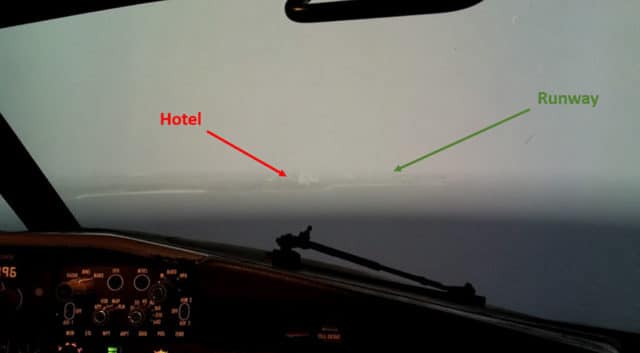 Visual references as seen in a flight simulator at approximately 500 feet AGL in poor visibility
Now, however, it became dreadfully clear that they weren’t where they thought they were. They were flying the aircraft straight into a tall building.
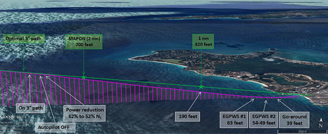
Normally, at this point of the approach, they would have been 320 feet above ground level but with the adjustments they’d made before entering the rain showers, they were now just 190 feet above ground level and descending at 940 feet per minute (15.7 feet per second).
With no landmarks or other visual clues, they weren’t sure what their height above the water was. The Pilot Flying advanced the throttles from 52% to 75% N1 and began to turn back to the right but the aircraft continued to descend at about 860 feet per minute.
At 63 feet above the sea, the enhanced ground proximity warning system (EGPWS) sounded: TOO LOW, TERRAIN. TOO LOW, TERRAIN.
The Pilot Flying pitched the nose up by 4°.
The EGPWS sounded again: TOO LOW, TERRAIN. The aircraft descended through 54 feet to 49 feet above ground level.
The aircraft was just 40 feet above the sea level and still 0.3 nautical miles from the runway threshold when the crew initiated a go-around.
 Standard 3° angle of descent versus the aircraft vertical approach path
The lowest altitude recorded by the EGPWS during the descent had been 39 feet AGL.
After the go-around, the controller instructed the crew to fly in a holding pattern because the visibility was too low to conduct the approach. The controller closed Runway 10 for departures and instructed the other aircraft on approach that the visibility had dropped below minimums and to fly in a holding pattern.
The final report from TSB Canada released the following findings:
Significant changes in visibility were not communicated to the crew, which allowed them to continue the approach when the visibility was below the minimum required to do so.
The reduction in the pitch attitude led to an increase in airspeed, which resulted in a reduction in engine thrust and a higher rate of descent than that required by the 3° angle of descent.
The occurrence of a moderate to heavy rain shower, after the aircraft crossed the missed approach point, led to a significant reduction in visibility. The low-intensity setting of the runway lights and precision approach path indicator lights limited the visual references that were available to the crew to properly identify the runway.
The features of a hotel located to the left of the runway, such as its colour, shape, and location, made it more conspicuous than the runway environment and led the crew to misidentify it as the runway.
The reduced visibility and conspicuity of the runway environment diminished the crew’s ability to detect that they had misidentified the runway.
The lack of visual texture and other visual cues available over water contributed to the crew’s inability to detect the aircraft’s height above the water.
An increase in visual workload led to inadequate altitude monitoring, which reduced the crew’s situational awareness. As a result, the crew did not notice that the aircraft had descended below the normal 3° angle of descent to the runway threshold.
It’s easy to dismiss this as a case of the flight crew trying to get in at any cost, dismissing the low visibility in their hurry to get landed. But based on the statements to the controller (again, the cockpit voice recorder data was overwritten so we don’t know what was discussed in the cockpit), the flight crew didn’t appear to have made a decision to attempt a landing in iffy conditions. They were never advised that the visibility had gone below minimums and mentioned that they could see the shoreline and then later that they had the runway in sight. They had prepared for an instrument approach and yet, despite the worsening conditions they continued flying visually. Neither noticed the lack of the PAPI or asked for brighter runway lighting. The response to the GPWS alert was slow: the crew didn’t increase thrust and initiate the go-around until the second alert. Up until that point, they clearly believed that the approach and landing could be done visually and remained fully committed to a visual landing in conditions that were such that–once they broke off their approach–the airport was closed until the weather passed.
The weather and the visibility finally improved about 45 minutes later. WestJet flight 2652 was cleared for the RNAV (GNSS) Runway 10 approach. This time, it went flawlessly and the aircraft landed safely at 16:18.
https://ift.tt/2wRCJXs
No comments:
Post a Comment